


Finiels

Jeff_314
User
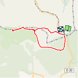

Length
6.9 km

Max alt
1699 m

Uphill gradient
171 m
Km-Effort
9.1 km

Min alt
1539 m

Downhill gradient
168 m
Boucle
Yes
Creation date :
2014-12-10 00:00:00.0
Updated on :
2014-12-10 00:00:00.0
2h18
Difficulty : Medium

FREE GPS app for hiking
 SityTrail
IGN / Geographical institutes
SityTrail Plus
The world is yours!
About
Trail Walking of 6.9 km to be discovered at Occitania, Lozère, Mont Lozère et Goulet. This trail is proposed by Jeff_314.
Description
Le sommet
Positioning
Country:
France
Region :
Occitania
Department/Province :
Lozère
Municipality :
Mont Lozère et Goulet
Location:
Mas-d'Orcières
Start:(Dec)
Start:(UTM)
561129 ; 4919276 (31T) N.
Comments
petite rando sympa a faire pour ses panoramas sur le sommet.